Showing posts with label Juneau. Show all posts

Monday, June 18, 2018

Flying on one of America's most unique commercial flights ~ Try an Alaska Airlines Milk Run

Other than Hawaii, the state of Alaska is one of the most unique states for transportation.  Because of the terrain and the fact that many areas are sparsely populated, the road system is minimal which leaves many areas inaccessible by car.  Juneau, the state capital, is the only US capital not connected to a road system.  With limited transportation options, everything must come from either air or water based transport.  Alaska Airlines has played a large role in aviation in Alaska with many routes serving the remote regions.  There are smaller feeder airlines that serve the VERY small and remote areas but Alaska Airlines mainly serves airports large enough to handle mainline jet aircraft.  

One of the more unique routes in the Alaska Airlines roster is what's affectionately known as Milk Runs.  Because everything must come by air or water, cargo can consist of not just mail and luggage but every day essentials like milk!, produce, dry goods, meats, bookshelves, TVs, car parts, office equipment and more.  If it's safe to transport by air, you can bet it's been shipped by Alaska Airlines.  Larger items like building materials, furniture, appliances, vehicles and mining equipment is usually transported by barge or the Alaska Marine Highway ferry.  Alaska Airlines can ship vehicles but that's uncommon for most people.  

In order to make transport as efficient as possible, Alaska Airlines daisy chains smaller cities rather than typical out and back routes which uses more resources.  While needed goods are brought in, produced goods like seafoods are shipped out.  Between Seattle and Anchorage, there are 6 major milk runs in operation today.  Flights 62, 64 and 66 are southbound routes from Anchorage to Seattle and Flights 61, 65 and 67 are northbound routes from Seattle to Anchorage.  The routes run in pairs, one north and one south.  Route 61 and 66, Route 64 and 65 and Route 62 and 67.  There are other routes that hop around but not in the same fashion as the above routes.  

If you're an aviation fan like myself, flying on one of these milk runs is something of interest and a badge of honor.  Unfortunately, you cannot just fly on one of these routes end to end.  For example, on Flight 64, you could not fly from Anchorage to Seattle.  You would have to fly from Anchorage to Ketchikan or any of the other stops.

I recently flew on Flight 67 from Anchorage to Juneau with stops in Cordova and Yakutat.  It was very interesting seeing the different people getting on and off and wondering about why they are coming or going to these remote places.  Since my trip was in June, it was a hodgepodge of locals, tourists, workers in the seafood industry and fishing enthusiasts.  

I was able to score a First Class upgrade which was nice not only for the bigger seat but also for the birds-eye view of the action.  From seat 1F, I could see all of the cargo coming and going as well as see all of the passengers.  All three flights were roughly 35 minutes in the air each.  When flying southbound, you'll want to sit on the left for best views and on the right on northbound flights.  Even though I was on the wrong side, the views are still great.  It's Alaska after all!

Once on the ground in Cordova, air-stairs are rolled up to the front door.  In years past, these routes were usually served by the 737-400 Combi which was half cargo and half passengers with boarding by the rear door.  Currently, these routes are mainly served by 737-800 aircraft and there are now dedicated cargo planes.

An unusual sight out the front door are trees.  Like a forest of trees rather than the concrete and metal jungle of most airports.  On this flight, about two thirds of the passengers disembarked and a handful boarded.  Cordova is a major seafood processing point so about two dozen boxes were loaded on.  We were on the ground for about 40 minutes before departing for Yakutat.

I enjoyed a quick slurp of whiskey before arriving in an even smaller airport.  A lot of grocery and household items came off here and a dozen passengers boarded.  The final leg to Juneau was jovial as most of the passengers who boarded in Cordova and Yakutat were headed to Seattle and beyond.


  • The reminder of the passengers who boarded in Anchorage disembarked in Juneau where a lot of people were waiting to board.  I really enjoyed this flight even though it took almost 4 hours compared to the nonstop flight which is about an hour and twenty minutes.  It's just a unique peek into the lives of those who venture to the remote parts whether to live, work, hunt or tour.  I hope to take a northbound milk run from Ketchikan to Juneau sometime.  

alaska airlines, milk run, flight 67, anchorage, cordova, yakutat, juneau
Flying to Cordova Alaska

alaska airlines, milk run, flight 67, anchorage, cordova, yakutat, juneau
Looking out the front door of the airplane in Cordova, Alaska

alaska airlines, milk run, flight 67, anchorage, cordova, yakutat, juneau
Cordova Alaska Airport terminal

alaska airlines, milk run, flight 67, anchorage, cordova, yakutat, juneau
Flying to Yakutat Alaska

alaska airlines, milk run, flight 67, anchorage, cordova, yakutat, juneau
Flying to Yakutat Alaska

Yakutat Airport terminal.  It's smaller than it looks

alaska airlines, milk run, flight 67, anchorage, cordova, yakutat, juneau
Downtown Juneau from the air


Airport Codes:

ANC - Ted Stevens Anchorage International Airport 
CDV - Merle K. (Mudhole) Smith Airport (Cordova)
JNU - Juneau International Airport
KTN - Ketchikan International Airport
PSG - Petersburg James A. Johnson Airport
SEA - Seattle–Tacoma International Airport 
SIT - Sitka Rocky Gutierrez Airport 
WRG - Wrangell Airport
YAK - Yakutat Airport 

Flight 61:
SEA-JNU
JNU-YAK
YAK-CDV
CDV-ANC

Flight 62:
ANC-JNU
JNU-SIT
SIT-KTN
KTN-SEA

Flight 64:

ANC-JNU
JNU-PSG
PSG-WRG
WRG-KTN
KTN-SEA

Flight 65:

SEA-KTN
KTN-WRG
WRG-PSG
PSG-JNU
JNU-ANC

Flight 66:

ANC-CDV
CDV-YAK
YAK-JNU
JNU-SEA

Flight 67:

SEA-KTN
KTN-SIT
SIT-JNU
JNU-ANC


~~~~~~~~~~~~~~~~~~~~~~~~~~~~~~~~~~~~~~~~~~~~~~~
Visit my and subscribe to my youtube channel!
Visit my ETSY shop!

All photos taken by Paul Clough.  
© All Rights Reserved.  Please contact for permission to use photos.

Thursday, June 14, 2018

Guide to hiking to the Mendenhall Glacier Ice Caves in Juneau, Alaska!

*** I added a video at the bottom! ***

Let me preface this article first with that I am by no means an expert!  I got lost a few times but eventually found my way.  I'm only writing this article as a tool to assist others in reaching the ice caves (though now melted).   You can read my article about the ices caves here.

If you're on this page, it's likely you've heard about or seen some photos of the Mendenhall Glacier Ice Caves.  They're a sight to behold!  But being made of ice, they do eventually melt which is the point of time we are at now.  That said, it's still worth the effort to hike to the... guess we'll just call it the front of the glacier.  For future reference, I'll refer to the ice caves as the glacier.

Getting to the trailhead:

I'm going to assume you can read a map but the main thing is getting on the Mendenhall Loop Road.  As you may have guessed, this road is a giant loop and when viewed on a map, the turnoff is roughly at the top, a little northwest.  You need to turn onto Montana Creek Road and follow it all the way to the end.  It turns into Skaters Cabin Road so don't make any turns off of the road.  Skaters Cabin Road dead ends at the West Glacier Trailhead. 

There are bathrooms but no running water. The trail entrance is to the left of the bathrooms.  About 100 feet in, you will find a trailhead board with information as well as a link to the USFS Map of the area.  If you have a smartphone with internet service, I'd advise downloading some sort of tracking app so if you get lost, you can backtrack.  There's also the 1910 cairn Marker which means at this point, the glacier was right where you're standing in 1910.  There will be many of these throughout the area, mostly near the lake.  A cairn is a marker made of rocks.  Some are official with the ice limit makers while others are merely there to mark the route.  

Hiking the trail:

The first 1.3 miles is fairly easy.  A few inclines and towards the end, you have a few steep inclines that zig zag.  There are cable hand rails but still be careful.  You will eventually reach a fork.  The sign below is located to the left of the trail.  


West Glacier Trail/View Point Cairn Fork Mid June 2018
West Glacier Trail/View Point Cairn Fork Mid June 2018

You have two options to get to the glacier.

The View Point Cairn Trail or the West Glacier Spur Trail. 

Both has advantages and disadvantages.  Looking at my GPS tracking log, they seem to be about the same length but the consensus is that the Cairn Trail is a bit shorter. 

West Glacier Trail:

First off, the West Glacier Trail goes on for quite a ways.  To the west of the glacier I'd imagine.  I missed the turnoff to the spur trail.  I'll come back to that in a minute.  Because I missed the spur, I ended up going up and up.  This however afforded me the nice view below. 


Mendenhall Glacier from West Glacier Trail Mid June 2018
Mendenhall Glacier from West Glacier Trail Mid June 2018

I was well into the "ribbon" section, I'll come back to that too, when I realized I was not on the spur trail so I back tracked.  I remember there being an obvious marker and sign but this sign has since been removed.  I was an idiot and forgot to take a photo but if you're using a GPS app, the spur should be about 2.1 miles from the trailhead.  You'll reach a viewpoint with a large 5 foot high boulder on the left.  The trail goes to the left and up but you'll notice a primitive trail that continues straight.  This is the spur trail.  There used to be a sign but it has been removed.  You can see the 2 bolts that held the sign so you'll know you're at the right spot.  From this point on, you're in the "ribbon" section.  This trail is not official like the West Glacier Trail.  This trail has been marked by guides and is fairly easy to navigate.  There are these colored plastic ribbons that are usually tied to trees and branches. The next one is usually in sight of the last one unless the trail is pretty obvious but you shouldn't go more than 200 feet without seeing one.

From the fork, you'll be looking for 2 main landmarks.  The large boulder which has a rope to help you up and down and the wood plank that crosses a creek.  Provided you pass these, you're on the right track.  From the plank, the trail gets a bit squirrely.  A lot of large flat rocks.  As you near the glacier, you'll have less vegetation until you reach the final embankment which is literally just a slope of loose rocks and gravel.  At this point, the route ribbons will be tied to rocks on the ground.  You will be at times sliding down so be very careful.  When you arrive at the bottom, you'll notice another trail.  That is the View Point Cairn Trail. 

The Glacier:

The first thing you'll notice is that it's dirty.  Nobody comes and cleans the damn glacier!  Okay, that's mother nature for you.  As I mentioned, the famed ice caves are no more.  I have the photo below which was taken last year around late June and below that is the photo I took this trip, mid June 2018.

Mendenhall Ice Caves Late June 2017
Mendenhall Ice Caves Mid June 2018
As you can see in the bottom photo, the caves have melted and the entrances are blocked.  Do NOT attempt to go in!  But it's amazing what a year does to this glacier. 

You can explore the seam but be careful.  What looks like openings are just small pockets.  Are there caves in there?  Maybe.  New caves open from time to time.  But for now, it's just a glacier. 

It's my opinion that it's easier to take the West Glacier Trail Spur to the glacier and the View Point Cairn Trail back. 


West Glacier Trail/View Point Cairn Fork Mid June 2018
Mendenhall Glacier from the View Point Cairn Trail Mid June 2018

View Point Cairn Trail:

From the glacier, it's a bit shifty.  Remember, this area was ALL under ice just a few years ago so little vegetation has grown.  As you start gradually ascending, there will be a spur trail to the left that leads to the lake.  This trail is mainly for kayakers and rafters who take the easy route.  Stay to the right and follow the ribbons.  You will pass many of the cairns (ice limit markers).  Maybe you'll find one with your birth year.  I did not.  There's a few 20 to 30 foot rock inclines you need to navigate.  Going back, you'll be going down.  Going to the glacier, you'll be climbing.  This route is a little more wet than the other route, at least this time around.  All in all, this trail stays close to the lake and at one point you'll be at the lake.  Then it goes up and up and up until you'll reach a USFS map sign like at the trailhead.  Go to the right and you'll intercept the main trail, then turn left to head back to the trailhead.

Map of hike:


Summary:


Is this hike worth it without the ice caves?  YES!  Even without the ice caves, it's still a beautiful, ever-changing piece of history that will not be here forever.  This is not a hike to do once but every time you visit Juneau.  While thousands and thousands visit the visitors center and nugget falls each day, very few actually get close enough to touch the glacier. 

Tips:

There are guides.  If you got the money, take one.  They also offer treks onto the glacier and when ice caves are available, into the caves. They provide all the necessary equipment. 

If you are stupid like me and go your own way, make sure you have the following:

Fully charged smart phone, ideally with 4G service.  Most cell phones do not have true GPS.  They still need the internet to download maps.  Download an app to track your route.  I used MapMyHike. 

Bring food and water.  At least 1 gallon per person and snacks that are high in protein.  Ideally, bring enough food for 2 meals.  If you get lost or stuck overnight, you'll need that food and water.

First Aid kit is a must

Bear spray is ideal but it's one of those things most tourists won't have because it's just a pain.  You can't take it on the plane so the likelihood you'll actually use it is low.  Check with your hotel or hostel.  They sometimes have loaners.

Layers of clothes, especially in the early and late seasons

Hard hat or helmet is good.  Good for cave exploration but also good for avoiding hitting your head on low branches. 

Gloves are great for grip and protection if you fall.  If you fall, chances are you'll land on your hands so gloves will save you from road rash. 

If you really want to get anal, you should have a paper map, a manual compass (or just a compass I guess), flash light, overnight survival gear, hiking boots and probably a few other things. 

Pay attention!  If you feel like you got off trail, especially in the ribbon section, STOP and backtrack to the last ribbon.  Carefully look for the next one.  Some are very small. 

Plan on at least 6 hours for an out and back trip.  It's roughly 3 miles each way. 

Summary again:

I hope this guide helps you and you read it before you head out, not when you're on the trail.  :)

Video:


~~~~~~~~~~~~~~~~~~~~~~~~~~~~~~~~~~~~~~~~~~~~~~~
Visit my and subscribe to my youtube channel!
Visit my ETSY shop!

All photos taken by Paul Clough.  
© All Rights Reserved.  Please contact for permission to use photos.

Sunday, May 6, 2018

Epic Photo Journey of Alaska ~ Alaska Railroad, scenic landscapes, Ice Caves and more!

I getting ready for my next trip to Alaska and I just love sharing my photos with friends and acquaintances but many have asked for an online album.  I made a nice little video for youtube featuring my favorite photos I've taken over several trips.  It's only about 150 out of thousands of photos but I think it gives you a pretty good look around Alaska.

From beautiful landscapes to trains to ice caves, you'll find a little of everything in my video.
Please enjoy and visit Alaska as it's much better in person!


~~~~~~~~~~~~~~~~~~~~~~~~~~~~~~~~~~~~~~~~~~~~~~~
Visit my and subscribe to my youtube channel!
Visit my ETSY shop!

All photos taken by Paul Clough.  
© All Rights Reserved.  Please contact for permission to use photos.

Sunday, August 13, 2017

Mount Roberts Tramway in Juneau


One of the top attractions in Juneau aside from the whale watching and the Mendenhall Glacier is the Mount Roberts Tramway.  It's also the closest and most accessible.  You'll find tickets very easily on the docks or through cruise ship companies or at the terminal at 490 S Franklin Street between the C and D dock.  Walk up tickets are $33 for an all day pass with discounts for children.  Trams are ADA accessible.

For the more adventurous, you can hike up and take the tram down for $10 or a receipt for $10 or more at the restaurant or gift shop.  The trailhead is located at 1001 Basin road, about a half mile from the docks.  The actual hike is about 2.5 miles to the tram.  It's fairly easy to moderate but can be slippery and muddy when rainy.  It's a nice hike up where you can have a drink or snack and ride the tram down.  

Once you're at the top, well, you're not at the top but at the tram station, there's a few trails you can take including to the peak as well as the popular Father Brown's Cross that overlooks the valley.  The Timberline Atop Mount Roberts is a full service restaurant and bar.  It's moderately priced which is nice since most places like this usually have sky high prices.  There's also a coffee and snack stand for people needing a quick bite.  There's also a gift shop for all your shopping needs.  

The Chilkat theater hosts frequent events like films and live performances.  Nearby the main building is the Nature Center which can help you identify the many animals and birds you may see on the mountain.  

The views are great... when the weather is nice.  If it's raining, foggy or cloudy, don't fret.  The weather changes quite often so spending an hour or two might lead to a break in the weather.  That's also the advantage of getting the full day pass as you can go back up later in the day or evening.  

I ended up hiking up.  It was rainy of course but was still a nice hike.  It took about two hours but I was going pretty slow.  I continued out to Father Brown's Cross and then headed to the main building.  After using the nice bathroom and chatting with some friendly staff, I had some beers and reindeer stew in the Timberline restaurant.  I showed my receipt and was able to ride down on the tram.  A very quick ride but still fun and better than hiking down. 

Although it's a tad pricey, it's definitely worth the trip up.  For more information, check out their website.  http://mountrobertstramway.com/ 

Mount Roberts Tramway in Juneau Alaska - Approaching docks


Mount Roberts Tramway in Juneau Alaska - Looking down at cruise ship docks

Mount Roberts Tramway in Juneau Alaska - Walkway between tram and restaurant

Mount Roberts Tramway in Juneau Alaska - Selfie looking down at bay

Mount Roberts Tramway in Juneau Alaska - Picnic site overlooking downtown


Mount Roberts Tramway in Juneau Alaska - Looking downtown at the docks

Mount Roberts Tramway in Juneau Alaska - Looking downtown at the docks

Mount Roberts Tramway in Juneau Alaska - Looking down at the bay

Mount Roberts Tramway in Juneau Alaska - Looking out towards Auke Bay

Mount Roberts Tramway in Juneau Alaska - View from hiking trail

Mount Roberts Tramway in Juneau Alaska - View from hiking trail

Mount Roberts Tramway in Juneau Alaska - Father Brown's Cross

Mount Roberts Tramway in Juneau Alaska - Father Brown's Cross

Mount Roberts Tramway in Juneau Alaska - Inside the tram


Mount Roberts Tramway in Juneau Alaska - Inside the tram


~~~~~~~~~~~~~~~~~~~~~~~~~~~~~~~~~~~~~~~~~~~~~~~
Visit my and subscribe to my youtube channel!
Visit my ETSY shop!

All photos taken by Paul Clough.  
© All Rights Reserved.  Please contact for permission to use photos.


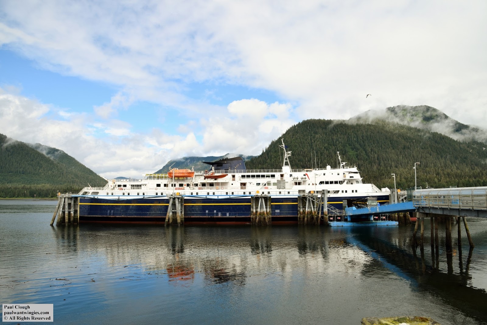
Alaska Marine Highway Matanuska - Trip Report

I took the famous but indispensible ferry system that links many of the remote communities along the Alaska coast.

I caught the ferry in Ketchikan after a week long stay.
Although cabins were available (I didn't price them but I'm sure they were out of my budget), I opted for the adventurous route which meant I was on my own for sleeping arrangements.  On this vessel, there are two places you can sleep.  The solarium which is outside but covered with heat lamps and in the recliner lounge.  You could also pitch a tent albeit at your own risk on the deck next to the solarium.  I chose the recliner lounger which was actually quite cold.  Like most, I hit the floor between the seats since it wasn't too crowded on this trip.

My destination was Juneau and there are a few routes from Bellingham or Prince Rupert during the summer.  I ferry I took came from Prince Rupert and was scheduled to stop in Wrangell, Petersburg, Kake and Sitka for a total travel time of 36 hours.  From Ketchikan, there was a faster ferry that bypassed Sitka but since the price was the same, I went with the longer route as it allowed me to do some additional sightseeing and I wanted to see Sitka just to say I've been there.  Plus ferries don't run at the same time every week so this particular routing got me to Juneau in the afternoon instead of 4 in the morning like some routes.

Most of the passengers had vehicles and or RV's and most of those opted for the cabins.  It's quite fascinating watching the process of unloading and loading vehicles at each port.  There was a 40 foot tour bus for the cruise ships, a large front loader, RV's from small to large and a few state vehicles as well as some cargo trailers.  You can really see how many of the remote communities rely on the ferries to bring everything from supplies to equipment to vehicles.

On the Matanuska, there's a cafeteria which serves up three meals a day with a rotating menu. This is not reheated food!  A full kitchen and staff cooks up classics as well as specials.  There was a Reuben sandwich for a dollar so I had to roll the dice on that for a midnight snack.  I also had a cheeseburger with fries which was quite good..  The prices overall were very reasonable and there was something for every budget.  If you happen to not have a budget, you're allowed to bring your own food and there's a microwave and toasters for use free of charge.  I brought a few things to stretch out my budget so it worked out nicely.  And there's not tipping because all employees on board are state employees so a tip would be like a bribe and that's not allowed.  They take cash and credit/debit.

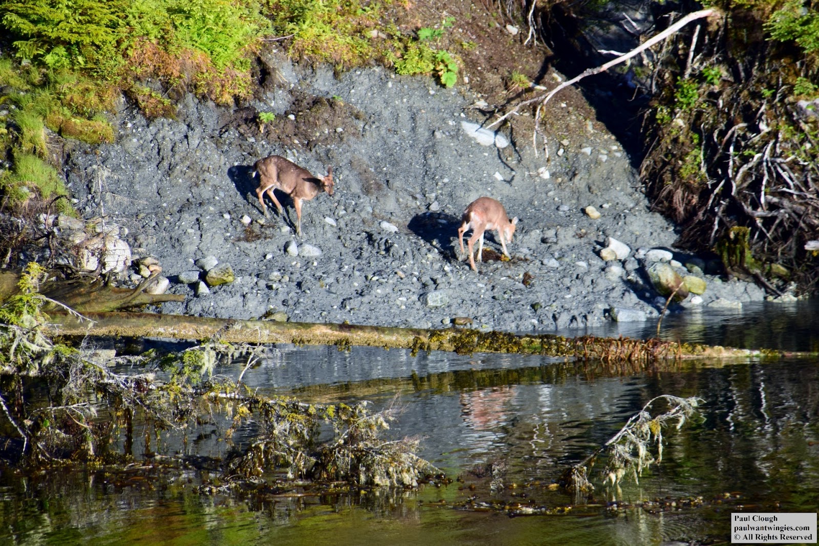
If you're into photography, there's no better way to see Alaska than by ferry or cruise ship.  You'll never know what you'll see.  I saw many bald eagles, a whale and some some deer.  Every trip is different.  And then there's the ever changing landscapes.  It's easy to get click happy and that can cause you to get photo'd out so pace yourself.  Also, be sure to bring warm clothes if you plan on shooting out on the deck.  It gets windy.  Most people shoot outdoors to avoid the reflections and glare of the windows.

In case watching the scenery is not enough for your pleasure, there are TV's in the recliner lounge which show various movies and a documentary about the Alaska Marine Highway.  There's a lounge that used to contain a bar but all of the bars were closed due to budget cuts so now it's just another lounge to sit in.  Sort of the quiet room so to speak. You're able to walk around most areas of the ship so you could get exercise as well.  You can also get off at ports and walk around.  Just make sure you take your boarding pass and ID and get back a few minutes before departure.  There was a three hour layover in Sitka so I took a short hike from the nearby trailhead... at 2 in the morning.

For people traveling without a cabin, there are public showers available.  You can't use them in port but once underway, you can use them.  Towels are available for rent but you can save a few bucks and bring your own. The water was surprisingly hot and good pressure.  After a day on the water and the hike in Sitka, it was nice to have a hot shower.

Taking the ferry was on my bucket list and I'm glad I can cross it off.  I would not hesitate to take the ferry again.  June 2017

Alaska Airlines airplane taking off from Petersburg

Outside the Sitka Ferry terminal

American Flag on the back of the Matanuska

The Matanuska in port in Kake

The Matanuska in port at Petersburg

Scenic view of the bay near the Sitka ferry terminal

Outside the Ketchikan ferry terminal in Alaska

Bald eagle at Ketchikan ferry terminal

Pair of bald eagles along the Alaska Marine Highway Ferry route

The shuttered bar on the Matanuska which is now just a lounge

Enjoying the recliners on the Matanuska Alaska Marine Highway ferry

Coast Guard helicopter flyby

Deer on island in the middle of the inside passage.  How did they get there?!
Deer on island in the middle of the inside passage.  How did they get there?!

$11.75 dinner on the Matanuska consisting of a cheeseburger with fries, a Reuben sandwich which was on sale for a buck and a soda.  Believe it or not, the Reuben was actually very good, well worth the gamble.  The cheeseburger and fries were also great.
$11.75 dinner on the Matanuska consisting of a cheeseburger with fries, a Reuben sandwich which was on sale for a buck and a soda.  Believe it or not, the Reuben was actually very good, well worth the gamble.  The cheeseburger and fries were also great. 

Enjoying the ever changing views on the Matanuska ferry

Ferry dock in Ketchikan, Alaska

Getting ready to take a hike near the ferry terminal in Sitka Alaska... at 2 AM

Microwave and toasters on the Matanuska are free of charge to use!

Public showers onboard the Matanuska

Ferry terminal in Sitka, Alaska. 5 AM

Vehicles waiting to board the Matanuska in Sitka

Vending machines aboard the Matanuska

Scenic views from the Matanuska

Scenic views from the Matanuska

Scenic views from the Matanuska

Scenic views from the Matanuska

RV being loaded onto Matanuska in Wrangell, Alaska


~~~~~~~~~~~~~~~~~~~~~~~~~~~~~~~~~~~~~~~~~~~~~~~
Visit my and subscribe to my youtube channel!
Visit my ETSY shop!

All photos taken by Paul Clough.  
© All Rights Reserved.  Please contact for permission to use photos.